


MOBILE MAPPING SOLUTION
Trimble MX9は、道路調査、地理情報、3Dモデリング、施設管理などの幅広いモバイルマッピングアプリケーションに対して、効率的で正確かつ大量のデータを取得するための車載用モバイルライダーシステム、マルチカメラ画像処理およびフィールドソフトウェアを組み合わせています。 革新的で軽量な設計により、簡単に設置できてさまざまな車両に設置できます。
タブレットやノートブックからアクセス可能な直観的なブラウザベースのフィールドソフトウェアにより、データ取得操作を迅速に実行し、システムのステータスと取得したデータの品質をリアルタイムで監視できます。
◆詳細は、カタログをダウンロードしてご覧ください。
このカタログについて
| ドキュメント名 | モバイルマッピングソリューション「Trimble MX9」 |
|---|---|
| ドキュメント種別 | 製品カタログ |
| ファイルサイズ | 226.3Kb |
| 登録カテゴリ | |
| 取り扱い企業 | 株式会社ニコン・トリンブル (この企業の取り扱いカタログ一覧) |
この企業の関連カタログ


このカタログの内容
Page1
DATASHEET
Trimble MX9
MOBILE MAPPING SOLUTION
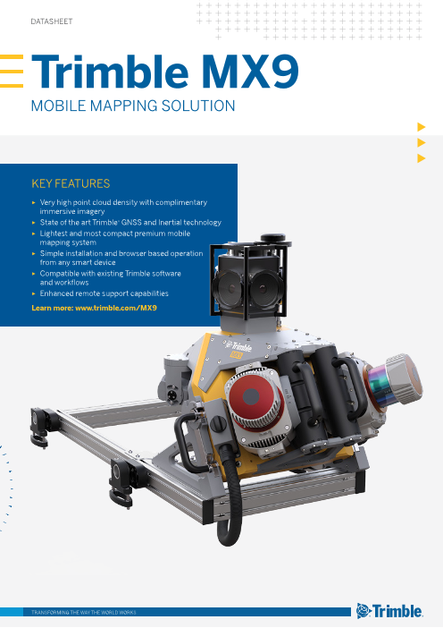
KEY FEATURES
► Very high point cloud density with complimentary
immersive imagery
► State of the art Trimble® GNSS and Inertial technology
► Lightest and most compact premium mobile
mapping system
► Simple installation and browser based operation
from any smart device
► Compatible with existing Trimble software
and workflows
► Enhanced remote support capabilities
Learn more: www.trimble.com/MX9
TRANSFORMING THE WAY THE WORLD WORKS
Page2
DATASHEET
Trimble MX9 MOBILE MAPPING SOLUTION
MX9 SYSTEM ELECTRICAL DATA
Effective measurement rate1 600 kHz 1 MHz 1.5 MHz 2 MHz Power supply input voltage 12VDC (12V–16V)
Scan speed (selectable) Up to 500 scans/sec Power consumption (typical) 350 W
Number of laser scanners 2, adjustable in 3 horizontal and
3 vertical positions
SYSTEM COMPONENTS
Sensor unit included
MX9 LASER SCANNER
Control unit included
Laser class 1, eye-safe
1 Power unit includedEFFECTIVE MEASUREMENT RATE 300 kHz 500 kHz 750 kHz 1 MHz
Maximum range, target Roof rack included, standard cross bars
reflectivity > 80%² 420 m 330 m 270 m 235 m not included
Maximum range, target Transport box included
150 m 120 m 100 m 85 m
reflectivity > 10%² Field software TMI, browser-based, no
Maximum number of targets per pulse practically unlimited installation necessary
Minimum range 1.2 m Cable, battery to power unit 5 m
Accuracy³ / precision⁴ 5 mm / 3 mm Cable, power unit to control unit 3 m
Field of view 360° "full circle" Cable, control unit to sensor unit 5 m
Data storage 1 set (2 x 2 TBytes SSD, removable)
EMBEDDED TRIMBLE GNSS-INERTIAL SYSTEM Control interface Tablet or Notebook, WiFi or
LAN cable, byod
IMU-Options AP60
ACCURACY - NO GNSS OUTAGES
3RD PARTY HARDWARE INTEGRATION OPTIONS
Position (m) 0.02–0.05
Synchronization output at sensor unit 1 (NMEA + PPS)
Velocity (m/s) 0.005
Roll and Pitch (deg) 0.005
ENVIRONMENTAL CHARACTERISTICS
Heading (deg) 0.015
Maximum vehicle speed
ACCURACY - 60 SECOND GNSS OUTAGE 110 km/h (68 mph)for data acquisition
Position (m) 0.02–0.05 IP rating IP64 (sensor unit)
Roll and pitch (deg) 0.005 Operating temperature 0 °C to +40 °C
Heading (deg) 0.015 Storage temperature -20 °C to +50 °C
ACCESSORIES Relative humidity (operating) 20 % to 80 %
GAMS yes, optional Relative humidity (storage) 20 % to 95 %
DMI5 yes, optional
PHYSICAL CHARACTERISTICS
CAMERAS Dimensions sensor unit 0.62 m x 0.55 m x 0.62 m
Camera type No Mounting FoV Focal length Weight sensor unit 37 kg
Spherical camera, 90% of full
1 fixed 4.4 mm Dimensions roof rack 1.03 m x 0.48 m x 0.28 m
30 MP (6 x 5 MP) sphere
Weight roof rack 18 kg
adjustable H: 53,1°
5 MP side looking camera 2 (in horizontal and 8.5 mm
vertical positions) V: 45,3°
5 MP backward/downward H: 53,1°
1 fixed 8.5 mm
looking camera V: 45,3° 1 Rounded values, selectable by measurement program.
2 Typical values for average conditions.
Capture modes by distance or by time at 10 fps max. 3 Accuracy is the degree of conformity of a measured quantity to its actual (true) value.4 Precision is the degree to which further measurements show the same results.
5 One sigma values, with DMI option, post-processed using base station data. Typical performance. Actual
results are dependent upon satellite configuration, atmospheric conditions and other environmental effects.
Specifications subject to change without notice.
NORTH AMERICA EUROPE ASIA-PACIFIC
Trimble Inc. Trimble Germany GmbH Trimble Navigation
10368 Westmoor Dr Am Prime Parc 11 Singapore PTE Limited
Westminster CO 80021 65479 Raunheim 3 HarbourFront Place
USA GERMANY #13-02 HarbourFront Tower Two
Singapore 099254
SINGAPORE
Contact your local Trimble Authorized Distribution Partner for more information
© 2018, Trimble Inc. All rights reserved. Trimble, and the Globe & Triangle logo, are trademarks of
Trimble Inc., registered in the United States and in other countries. All other trademarks are the
property of their respective owners. PN 022516-357C (03/18)
TRANSFORMING THE WAY THE WORLD WORKS www.trimble.com