


超高層ビルの3D データの取得、大規模インフラ施設の文書化、広大な露天掘り施設のスキャニングなど、安全な場所からスキャンでき、また、少ない計測点による作業時間の短縮で生産性が飛躍的に向上します。
◆詳細は、カタログをダウンロードしてご覧ください。
このカタログについて
| ドキュメント名 | Leica ScanStation P50 3次元レーザースキャナー |
|---|---|
| ドキュメント種別 | 製品カタログ |
| ファイルサイズ | 524.6Kb |
| 登録カテゴリ | |
| 取り扱い企業 | ライカジオシステムズ株式会社 (この企業の取り扱いカタログ一覧) |
この企業の関連カタログ


このカタログの内容
Page1
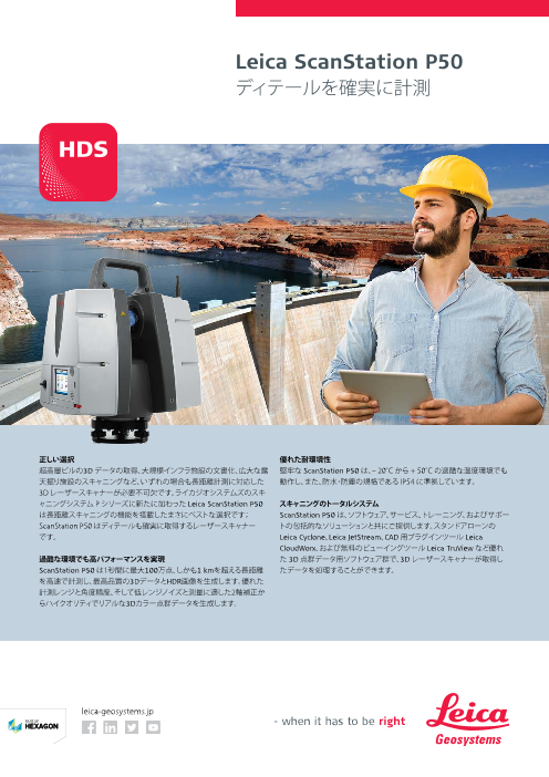
Leica ScanStation P50
ディテールを確実に計測
正しい選択 優れた耐環境性
超高層ビルの3D データの取得、大規模インフラ施設の文書化、広大な露 堅牢な ScanStation P50 は、– 20°C から + 50°C の過酷な温度環境でも
天掘り施設のスキャニングなど、いずれの場合も長距離計測に対応した 動作し、また、防水・防塵の規格である IP54 に準拠しています。
3D レーザースキャナーが必要不可欠です。ライカジオシステムズのスキ
ャニングシステム P シリーズに新たに加わった Leica ScanStation P50 スキャニングのトータルシステム
は長距離スキャニングの機能を搭載したまさにベストな選択です; ScanStation P50 は、ソフトウェア、サービス、トレーニング、およびサポー
ScanStation P50 はディテールも確実に取得するレーザースキャナー トの包括的なソリューションと共にご提供します。スタンドアローンの
です。 Leica Cyclone、Leica JetStream、CAD 用プラグインツール Leica
CloudWorx、および無料のビューイングツール Leica TruView など優れ
過酷な環境でも高パフォーマンスを実現 た 3D 点群データ用ソフトウェア群で、3D レーザースキャナーが取得し
ScanStation P50 は1秒間に最大100万点、しかも1 kmを超える長距離 たデータを処理することができます。
を高速で計測し、最高品質の3DデータとHDR画像を生成します。優れた
計測レンジと角度精度、そして低レンジノイズと測量に適した2軸補正か
らハイクオリティでリアルな3Dカラー点群データを生成します。
leica-geosystems.jp
Page2
Leica ScanStation P50
テクニカルデータ
性能 電力
単発測定精度 * 電源 24 V DC, 100 – 240 V AC
距離精度 1.2 mm + 10 ppm( 120 m/270 mモード) バッテリータイプ 2 x 内蔵リチウムイオン;外付け リチウムイオン
3 mm + 10 ppm( 570 m/ > 1kmモード) (外部ポートで接続, 同時使用, ホットスワップ可能)
測角精度 8”( 水平); 8”( 鉛直) 連続使用時間 内蔵バッテリー: 5.5 h( 2個)
ターゲット測定精度 ** 2 mm( 50 m までの標準偏差) 外付けバッテリー: 7.5 h( 室温)
2軸コンペンセータ リアルタイムコンペンセータ搭載液体センサー, オン / 動作環境
オフ切替可, 分解能 1”, ダイナミックレンジ ± 5’, 精度 動作温度範囲 -20℃ ~ +50℃
1.5” 保管温度範囲 -40℃ ~ +70℃
レーザースキャニングシステム 湿度 95 %, 結露しないこと
レーザータイプ 超高速タイムオブフライト方式のレーザー, ウェーブ 防塵 / 防水 IP54 (IEC 60529)
フォームデジタイジング (WFD) テクノロジー搭載
外観
レーザー波長 1550 nm( 不可視) / 658 nm( 可視)
スキャナー
レーザークラス 1 (IEC 60825:2014) 寸法 (D × W × H) 238 mm × 358 mm × 395 mm
ビーム拡散度 < 0.23 mrad( FWHM, フルアングル) 重量 12.25 kg( バッテリーなし)
前面ウィンドウでのビーム径 ≦ 3.5 mm (FWHM) 内蔵バッテリー
測定範囲と反射率 最短測定可能距離 0.4 m 寸法 (D × W × H) 40 mm × 72 mm × 77 mm
重量 0.4 kg
最大測定可能距離 反射率 マウント 直立または逆さま
120 m 8% 操作オプション
270 m 34% フルカラー タッチスクリーンのオンボードコントロール
570 m 60% リモートコントロール:Leica CS10/CS15/CS20/CS35 コントローラ, または iPad, iPhone を
>1 km 80% 含む他のリモートデスクトップデバイスを使用; 外部シミュレータ
スキャンスピード 最大 1,000,000点 / 秒 主な機能
レンジノイズ * 10 m: 0.4 mm rms スキャニングワークフローおよび クイックオリエンテーション, アジマス設定, 既知の
50 m: 0.5 mm rms オンボードレジストレーション バックサイト, 削除(4/6パラメータ), トラバース
スキャン範囲 チェックアンドアジャスト 角度パラメータ, 傾き補正, レンジオフセットを現場で
水平 360° チェック
鉛直 290° ターゲットの選択 ビデオまたはスキャンから選択
データ保存容量 256 GB( 内蔵SSD) または外部 USB デバイスまたは ユーザーインターフェースの選択 ベーシック / アドバンスの切替え可能
外部 USB デバイス ワンボタンスキャン ワンボタンでスキャンを実行
通信 / データ転送 無線 LAN または USB 2.0 接続のギガビットイーサ
スキャン範囲の定義 ビデオまたはスキャンからスキャン範囲を設定;
ネット
バッチ処理スキャニング
オンボード ディスプレイ フルカラータッチスクリーンディスプレイ タッチペン
付き, VGA( 640 x 480 ピクセル) ご注文に関する情報
レーザー求心装置 レーザークラス 1 (IEC 60825:2014) ライカジオシステムズ、または正規代理店にお問合せください。
求心精度: 1.5 mm@1.5 m
レーザーポイント径: 2.5 mm@1.5 m
オン / オフ切替可能
イメージングシステム このカタログの仕様および製品の外観は、改良のため予告なく変更する場合があります。
内蔵カメラ すべての精度の ± 表記は特に記載がない限り 1 シグマでの値です。
*
解像度 シングル 17° x 17° カラー画像(4メガピクセル); アルベド 78 % の場合
** 4.5" 白黒ターゲットのフィッティングアルゴリズムによる
パノラマ画像(700メガピクセル)
ピクセルサイズ 2.2 µm スキャナー: IEC 60825:2014 に準じたレーザークラス1製品レーザー求心装置: IEC 60825:2014 に準じたレーザークラス1製品
ビデオ ズーム付きストリーミングビデオ; 自動露出調整から
アンビエント照明 iPhone、iPad は Apple Inc. の登録商標です。
ホワイトバランス 晴天, 曇天, 暖色・寒色照明, 任意設定
HDR トーンマッピング / フルレンジ イラスト、説明、技術データは変更されることがあります。無断複写・複製・転載を禁じます。
Copyright Leica Geosystems AG, Heerbrugg, Switzerland 2017. 869813ja - 10.17
外付けカメラ キャノン EOS 60D/70D/80D をサポート
Leica ScanStation P30/P40 Leica ScanStation P16 Leica Cyclone REGISTER 360
Because every detail matters Because every detail matters The power of Cyclone,
simplified
The right choice Reduced downtime Easy-to-use Reduced downtime
Whether capturing 3D geometry of roads, rails, tunnels and The extremely durable new laser scanners perform even under The Leica ScanStation P16 features an intuitive and user-friendly The extremely durable new laser scanner performs even under
bridges or high-definition scan data for topographic maps and the toughest environmental conditions, such as extreme touch screen interface. The one-touch scan button and wizard the toughest environmental conditions, such as extreme
as-built surveys, you know you’ll need an accurate long range temperatures ranging from – 20°C to + 50°C and comply with the style software guarantee an easy workflow and enable a fast temperatures ranging from – 20°C to + 50°C and complies with
scanning tool for your projects – the new ScanStation laser IP54 rating for dust and water resistance. data check in the field. Combined with WLAN remote control, the the IP54 rating for dust and water resistance.
scanners from Leica Geosystems are the right choice, because Leica ScanStation P16 can be operated by any handheld device.
every detail matters. Complete scanning solution Complete scanning solution
Speed Scale Simplicity
Leica Geosystems offers the new Leica ScanStation portfolio Value for money Leica Geosystems offers the new Leica ScanStation portfolio
High performance under harsh conditions as an integrated part of a complete scanning solution including Its attractive price-performance ratio, worldwide support and as an integrated part of a complete scanning solution including
Drag, Drop, Done. From project creation Cyclone REGISTER 360 handles even the Deliver professional-level project
The Leica ScanStations deliver highest quality 3D data and HDR hardware, software, service, training and support. 3D laser quality service from Leica Geosystems result in a low cost of hardware, software, service, training and support. 3D laser
to final reporting, project completion is most complex of projects with ease and deliverables with ease. Leica Cyclone
imaging at an extremely fast scan rate of 1 mio points per scanner data can be processed in the industry’s leading 3D ownership and make the Leica ScanStation P16 the perfect scanner data can be processed in the industry’s leading 3D
significantly faster thanks to multi- takes the headache out of projects with REGISTER 360 provides guided registration
second at ranges of up to 270 m. Unsurpassed range and angular point cloud software suite, which consists of Leica Cyclone solution for companies entering the laser scanning business. point cloud software suite, which consists of Leica Cyclone
threaded batch routines, one-step import hundreds of scans. New users can workflows to assist new users and speed
accuracy paired with low range noise and survey-grade dual-axis stand-alone software, Leica CloudWorx plug-in tools for CAD stand-alone software, Leica CloudWorx plug-in tools for CAD
and processing, guided workflows, execute large projects, scaling to your the process for experienced users. Intuitive
compensation form the foundation for highly detailed 3D colour systems and the free Leica TruView. systems and the free Leica TruView.
built-in QA/QC tools and automated needs, thanks to the simple-yet-powerful QA tools and reporting take the guesswork
point clouds mapped in realistic clarity.
reporting to save significant time and interface. out of your registration quality and put all
安心のお客様サポ-ト guess-work while delivering higher the information you need at your productivity. fingertips. Batch export your final products to a range of formats and programs and even push live data to the cloud for global
collaboration with the click of a button.
アクティブ カスタマーケアはライカジオシステムズとお客様の真のパートナーシップの証です。 leica-geosystems.com
カスタマーケア パッケージ (CCP) は、ハードウェアに最適なメンテナンスを、ソフトウェアには
最新バージョンを提供し、お客様がベストな成果を得られるようサポートします。ポータルサイト Leica ScanStation Leica ScanStation P16 Leica Cyclone
myWorld@Leica Geosystems では有益な情報を1日24時間365日提供しています。 P40/P30 REGISTER 360
〒108-0073 東京都港区三田1-4-28 三田国際ビル18F Tel. 03-6809-4925
leica-geosystems.co.jp