


屋内/屋外問わずレジストレーション無しでスキャンが可能で、ライカのレーザースキャナーおよびトータルステーションへ接続して3Dデータの取得と所有されている弊社のシステムの生産性を向上します。
◆詳細は、カタログをダウンロードしてご覧ください。
このカタログについて
| ドキュメント名 | Leica ProScan モバイル・レーザースキャナー・システム |
|---|---|
| ドキュメント種別 | 製品カタログ |
| ファイルサイズ | 722.2Kb |
| 登録カテゴリ | |
| 取り扱い企業 | ライカジオシステムズ株式会社 (この企業の取り扱いカタログ一覧) |
この企業の関連カタログ


このカタログの内容
Page1
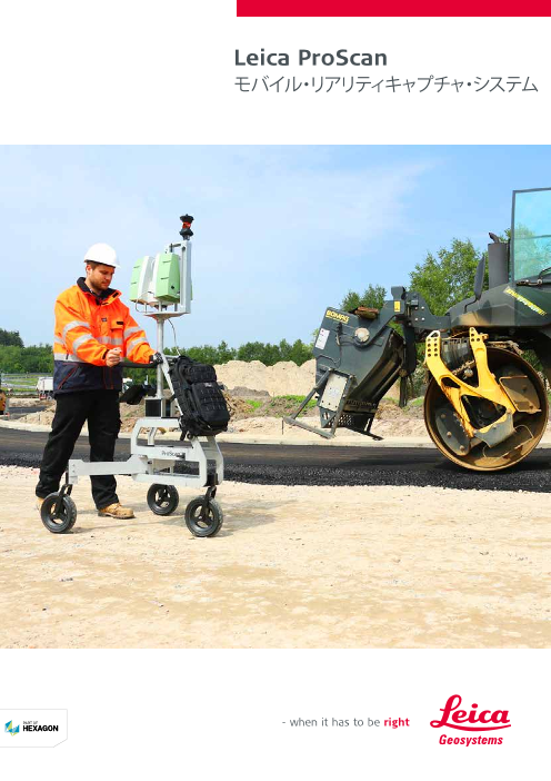
Leica ProScan
モバイル・リアリティキャプチャ・システム
Page2
Leica ProScan –
レーザースキャナーとモバイルプラットフォーム の融合
ProScan キネマティックレーザースキャニングは、計測システムの統合、ソフトウェア GUI 設計、データ処理技術の最先端の組み合わ
せで、3D で現実を把握します。比類ないパフォーマンスは、レーザースキャニングの高い生産性と現場の作業時間を最大 90% 削減す
ることによって結果を得るまでの時間を短縮し、新たな基準を提唱します。
軌跡を定めるための自動 TPS トラッキング機能により高速でデータを取得できます。スキャン範囲最大15m、点精度数ミリメートルで
屋内外の環境をトラッキングし新しい次元を開きます。一箇所に留まることなく自由にスキャンすることができます。
IMU
T シリーズ G シリーズ I シリーズ
TPS トラッキングとポジショニ GNSS ポジショニング IMU ポジショニング
ング
ProScan とディファレンシャルモードの ProScan のトラッキング技術により、3D
ProScan の TPS トラッキングは、システ GNSS レシーバーの組み合わせにより、 データを取得しながら IMU をキャリブ
ムの軌道を追尾し、高精度の結果を得る 最適なポジショニングが可能です。 レーションします。
ことができます。
データキャプチャ・ワークフロー
ProScan は最新のキネマティックレーザースキャニングアルゴリズムと近代的な
GUI を組み合わせた直感的な単一インターフェースで動作します。このソフトウ
ェアは単一のシームレスな GUI で、軌跡の処理とポイントクラウドの計算をしま
す。必要な処理とワークフローを効率的に制御し、調整します。
WORKFLOW Project planning Platform Data capture Point cloud configuration generation
SOFTWARE Project Platform PScan
Page3
主な活用現場
Leica ProScan は屋内外を問わず広範囲のアプリケーション
で活用することができます。データ計測のコスト削減がもたら
す高い生産性は、より多くのデータ計測の機会を創出します。
トンネル検査、アスファルトの平坦性
製造ラインの最適化
Point cloud
generation DATA READY
FOR FEATURE
PCloud EXTRACTION
BIM モデルへのデータ生成
Page4
およそ200年にわたり計測・測量の製品および技術で変革を生んできたライ
カジオシステムズは、世界中のプロフェッショナルに向けて新たなトータルソ
リューションを開発しました。優れた製品と革新的なソリューションの開発で
知られているライカジオシステムズは、地理空間情報の取得・解析・提案にお
いて、測量・土木・安全・防災・建築・建設・電力・大規模施設など実に多岐に
わたる業界のプロフェッショナルから信頼を得ています。ライカジオシステム
ズは高品質の機器、洗練されたソフトウェア、そして信頼できるサービスで、
未来を創造する皆さまに価値ある技術を日々提供してまいります。
ライカジオシステムズは Hexagon( ナスダック・ストックホルム: HEXA B;
hexagon.com)のメンバーで、地理空間および企業アプリケーションに最高
の品質と生産性をもたらす情報技術を提供するグローバルカンパニーです。
イラスト、説明、技術データは変更されることがあります。無断複写・複製・転載を禁じます。
Copyright Leica Geosystems AG, Heerbrugg, Switzerland, 2016.
865589ja – 10.16
Leica ProScan Leica ScanStation P30/P40 Leica Nova MS60 Leica Pegasus:Backpack
Mobile reality capture Because every detail matters Data sheet Mobile reality capture
Wichmann
Innovations
Award
The right choice Reduced downtime
Engaging software Infinitely bridging Customer care is only
Whether capturing 3D geometry of roads, rails, tunnels and The extremely durable new laser scanners perform even under
the field to the office a click away
bridges or high-definition scan data for topographic maps and the toughest environmental conditions, such as extreme
as-built surveys, you know you’ll need an accurate long range temperatures ranging from – 20°C to + 50°C and comply with the The Leica Nova MS60 MultiStation comes While Leica Captivate captures and Through Active Customer Care (ACC),
scanning tool for your projects – the new ScanStation laser IP54 rating for dust and water resistance. with the revolutionary Leica Captivate models data in the field, Leica Infinity a global network of experienced
scanners from Leica Geosystems are the right choice, because software, turning complex data into processes the information back in the professionals is only a click away to
every detail matters. Complete scanning solution the most realistic and workable 3D office. A smooth data transfer ensures expertly guide you through any problem.
Productivity boost Maximum flexibility Intuitive workflow Leica Geosystems offers the new Leica ScanStation portfolio models. With easy-to-use apps and the project stays on track. Leica Eliminate delays with superior technical BIM & infrastructure documentation Industrial training Security & disaster response
High performance under harsh conditions as an integrated part of a complete scanning solution including familiar touch technology, all forms of Captivate and Leica Infinity work in service, finish jobs faster with excellent
ProScan kinematic laser scanning The high speed data acquisition is ProScan runs with an intuitive The Leica ScanStations deliver highest quality 3D data and HDR hardware, software, service, training and support. 3D laser measured and design data can be viewed conjunction to join previous survey consultancy support, and avoid costly site The Leica Pegasus:Backpack enables Better understand the landscape you Make faster and better decisions
platform combines the latest supported by TPS-bases tracking single-interface software combining imaging at an extremely fast scan rate of 1 mio points per scanner data can be processed in the industry’s leading 3D in all dimensions. Leica Captivate spans data and edit projects faster and revisits with online service to send and regular indoor data capture for efficient are operating in, by creating reality based on accurate data to develop
advancements in measurement system functionality automatically modern GUI concepts with the second at ranges of up to 270 m. Unsurpassed range and angular point cloud software suite, which consists of Leica Cyclone industries and applications with little more efficiently. receive data directly from the field. and cost-effective building documentation, based 3D industrial training evacuation plans, map routes and be
integration, software GUI designs and determining trajectory and opening latest developments in kinematic accuracy paired with low range noise and survey-grade dual-axis stand-alone software, Leica CloudWorx plug-in tools for CAD more than a simple swipe, regardless Control your costs with a tailored Customer milestone approval and payment validation. environments and documenting any site informed of any area changes, even in
data processing technologies to up a new dimension to capture laser scanning algorithms. The compensation form the foundation for highly detailed 3D colour systems and the free Leica TruView. of whether you work with GNSS, Care Package, giving you peace of mind This wearable reality capture solution delivers changes in 3D to. Enhanced trajectory pedestrian-only, underground or
capture reality in 3D. Unmatched indoor and outdoor environments software processes trajectories and point clouds mapped in realistic clarity. total stations or both. you’re covered anywhere, anytime. complete as-built 3D point cloud and image calculation with SLAM technology for GNSS-denied zones. Cut down
performance sets new standards in and results in point accuracies in computes point clouds in one data in an authoritative and professional indoor mapping purposes makes response time and capture critical data
laser scanning productivity and time to the order of a few millimetres for seamless graphical user interface. way, bringing practical productivity for BIM to updating 2D and 3D drawings easier in disaster areas by efficiently mapping
results by cutting up to 90% of the scanning ranges up to 15 metres Efficiently control and steer the the next level and making indoor reality while adding the further value of the area on foot to ultimately save
time spent in the field. whilst moving absolutely freely. required processes and workflows. capture easy. Quickly report powerline combining images and LiDAR. lives and minimise damage.
clearances of critical infrastructures.
Leica ProScan Leica ScanStation Leica Nova MS60 Leica Pegasus:
P30/P40 Backpack
● お問い合わせ: di@leica-geosystems.co.jp
〒108-0073 東京都港区三田1-4-28 三田国際ビル18F Tel. 03-6809-4965
leica-geosystems.co.jp
© 2016 Hexagon AB and/or its subsidiaries and affiliates.
Leica Geosystems is part of Hexagon.